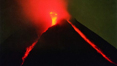
Mount Merapi, Indonesia 2010
Location
Mount Merapi (meaning Mountain of Fire) is an active stratovolcano (or composite volcano) located in south-east Asia, on the island of Java, Indonesia, a lower middle income country (LMIC). It is the most active volcano in Indonesia, having erupted regularly since 1548.
Merapi is located in one of the most densely populated parts of Java with over 11,000 people living on the slopes of the mountain. Most of these people are poor farmers who depend on the richness of the soil for their living. People choose to live in volcanic areas despite the risks of an eruption. Volcanoes can provide people with many benefits such as:
- volcanic rock and ash provide fertile land which results in a higher crop yield for farmers
- tourists are attracted to the volcano, which increases money to the local economy
- geothermal energy can be harnessed, which provides free electricity for locals
- minerals are contained in lava, eg diamonds - this can be mined to make money
In March 2010 there were first signs that the volcano would erupt. A device that measures any changes in the 'tilt' of the landscape. It is used often for studying volcanoes. showed that the volcanic dome had begun to bulge. In September there was increased earthquake activity and white plumes of smoke were seen rising above the volcano's crater. On Monday 25 October 2010, Merapi erupted and continued to erupt until 30 November.
Causes
The volcano and its eruptions were caused by the Indo-Australian plate being When one crustal plate is forced beneath the other. beneath the Eurasian plate. The volcano is located on a When two tectonic plates move towards one another. The oceanic crust is forced to sink back into the mantle, whilst the continental crust rises above. Volcanoes and earthquakes are found here., at a subduction zone, part of the Pacific Ring of Fire.
Physical impacts
- Volcanic bombs and heat clouds, with temperatures up to 800°C, spread over a distance of 10 kilometres.
- Pyroclastic flows travelled three kilometres down the heavily populated mountain sides.
- Volcanic ash fell up to 30 kilometres away and travelled six kilometres into the sky.
- Villages, such as Bronggang, 15 kilometres from the volcano, were buried under 30 centimetres of ash.
- sulfur dioxide was blown across Indonesia, the Indian Ocean and as far south as Australia.
Social and economic impacts
- Ash clouds caused major disruption to aviation across the region.
- Roads were blocked with cars and motorcycles as residents tried to flee the hazard zone.
- Vegetable prices increased because of the damage to crops.
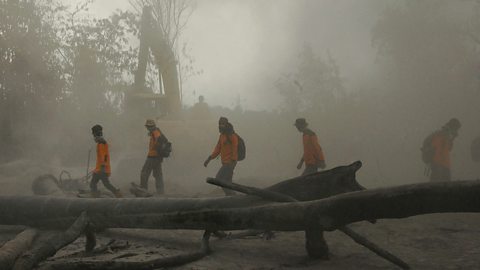
- 350,000 people living in the area had to flee their homes.
- Heavy rain on 4 November 2010 caused A destructive volcanic landslide or mudflow, consisting of a mixture of volcanic debris, mud, rock and water., washing ash and rock down into towns and destroying bridges.
- Schools were closed.
Long-term impacts
Physical
- Ash will eventually lead to more fertile soils in the area.
- New data from the eruption has enabled hazard mapping to be updated and used to set up exclusion zones around the volcano.
Social and economic
- 353 people were killed and 577 people were injured.
- Overcrowded evacuation centres led to poor sanitation, no privacy and a serious risk of disease.
- People, particularly farmers, lost their homes and livelihoods.
- 350,000 people were made homeless.
Responses to reduce the risk
- 210 evacuation centres were set up in schools, churches, stadiums and government offices.
- An exclusion zone of 20 kilometres was established around the volcano.
- Indonesian Disaster Management Agency mobilised volunteers, the military and police to circulate information, rescue survivors, control traffic, set up makeshift hospitals and kitchens in evacuation centres.
- International aid was offered from governments and A company that does not work for the government, eg a charity. such as the Red Cross and Red Crescent.
Responses to increase the capacity to cope
- 2,682 people were moved to new, safer houses permanently.
- The government made money available to farmers to help replace their livestock.
- The government set up a special taskforce to support people who were affected by the volcano, either by family issues, or because they lost their jobs.
- An ongoing exclusion zone of 2.5 kilometres was set up, settling people in areas of lower risk.
- Improved prediction measures and education in evacuation procedures have been introduced.
- Dams have been built in valleys to hold back lahars.